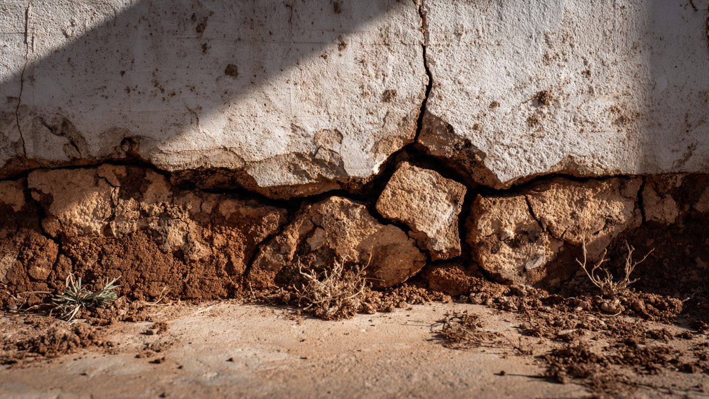
Montmorillonite clay can generate pressures exceeding 30,000 pounds per square foot when it gets wet. That is roughly the weight of a loaded cement truck concentrated on a single floor tile. The mineral absorbs water into its crystal lattice and swells to fifteen times its dry volume, then shrinks when the moisture leaves, and this cycle repeats with every season, every irrigation change, every plumbing leak, every rerouted downspout.
According to the Virginia Department of Energy, citing USDA and ASCE data, half of American homes sit on expansive soils. A quarter have already suffered damage. Annual losses hit $7 billion, which is more than earthquakes, tornadoes, and hurricanes combined.
Standard homeowner’s insurance does not cover it.
What a $2,900 Report Actually Tells You
A geotechnical investigation for residential construction costs $1,000 to $5,000, with a national average around $2,900. For that price, an engineer drills two bore holes 15 to 20 feet deep, collects soil samples, runs lab tests for bearing capacity and moisture content, and writes a report recommending a foundation type.
Two bore holes on a 10,000-square-foot lot. Each sample represents a cylinder roughly four inches in diameter. Combined, they cover about 25 square inches of a 1.44-million-square-inch property. That is 0.0017% of your lot.
Additional borings cost $300 to $900 each. Builders rarely order them unless the first two results diverge enough to scare the engineer, because every extra boring adds cost to a project where the client is already questioning why they need a soil test at all.
The report is not wrong. It accurately describes what exists at two specific points. It is incomplete, and the margin between accurate and sufficient is where foundations crack.
Who Gets to Skip the Report
Geotechnical requirements vary wildly by jurisdiction. California counties like Santa Cruz require reports for all new habitable structures, major additions, and retaining walls over four feet. Sonoma County publishes a specific technical bulletin defining when investigation is mandatory. Seattle requires a licensed PE with demonstrated geotechnical expertise.
Many jurisdictions allow waivers. If the lot sits in an area with known stable soils and the building official signs off, you can skip the report entirely. Some production builders in Texas, Arizona, and parts of the Southeast build hundreds of homes a year on expansive clay without site-specific geotechnical investigations, relying instead on a regional report that covers the entire subdivision from a single set of borings the developer commissioned years ago.
The developer’s report describes what the soil looked like before grading crews moved 10,000 cubic yards of fill across the site. It does not describe what sits under your specific pad after that work was done.
What Happens When It Goes Wrong
Foundation repair costs range from $300 for hairline cracks to $35,000 for major structural stabilization. Piering alone runs $1,000 to $3,000 per pier, and a typical residential job requires eight to twelve piers. Basement foundation repair averages $5,000 to $15,000. Slab repair runs $3,000 to $7,500.
In Haynes v. Intermountain GeoEnvironmental Services (Utah, 2019), homeowners noticed foundation cracks about a year after construction. The soil was unstable. They sued the geotechnical firm that had written the report, but the court dismissed the claims. The firm had been hired by the developer, not the homeowner. Under the economic loss doctrine, the homeowner had no direct contractual relationship and could not recover in tort.
Read that again. The geotechnical report existed. It was prepared for your lot. But it was prepared for someone else, and the law says that someone else is who it protects.
Machine Learning Can See Between the Holes
The USDA maintains the Soil Survey Geographic Database (SSURGO), a spatially referenced dataset covering most of the continental United States. It maps soil types, textures, drainage characteristics, and parent materials down to the county level. Most builders have never heard of it.
A 2025 study in MDPI’s Geotechnics journal demonstrated physics-constrained machine learning models that predict soil type and bedrock depth by combining SSURGO data with boring logs and soil color measurements at multiple depth intervals. The models use Map Unit Keys to link spatial soil polygons to detailed attribute tables, then add USDA soil color data at 25, 50, 75, 100, and 125 centimeter depths as additional training features. Critically, the models are physics-constrained, meaning predictions must respect known physical relationships between soil properties rather than relying purely on statistical correlations.
Separate research in MDPI Geosciences applied interpretable AI to soil liquefaction assessment, producing models that flag high-risk zones before a single boring is drilled. The interpretability matters. A black-box prediction that says “this soil is risky” is useless to an engineer who needs to sign a report. A model that explains which variables drove the prediction and how they interact is a tool the engineer can evaluate.
Seequent, a Bentley Systems subsidiary, is building a commercial platform around this concept. Their VP of Labs, Dr. Alexandre Boucher, identifies the core problem: geotechnical data is scattered across project files, individual hard drives, and incompatible formats. OpenGround, their cloud platform, added direct field-to-lab data transfer in February 2026. The goal is obvious: consolidate enough boring data from enough sites that ML models can predict soil conditions at locations that have never been drilled.
What This Means for Residential
Commercial geotechnical firms already use geostatistical interpolation to estimate conditions between borings on large sites. Kriging and inverse distance weighting are standard practice. ML models trained on SSURGO and regional boring databases extend the same logic to residential lots, where budget constraints make extra borings impractical.
Imagine ordering a geotechnical report and receiving not just the results of two borings, but a probability map of your entire lot. The northwest corner has a 78% likelihood of containing high-plasticity clay below eight feet. The southeast shows stable sandy loam throughout the profile. The model recommends a third boring at a specific coordinate where uncertainty is highest, rather than placing it where the drill rig parks most conveniently.
The technology to build that map exists. SSURGO is free and public. The ML research is peer-reviewed and published. Seequent’s commercial platform is operational. What does not exist, not yet, is a residential-focused product that packages this for a builder who wants to know whether $300 for one more boring at coordinate X will save $15,000 in foundation remediation later.
The Regulatory Gap
No U.S. building code currently recognizes ML-augmented geotechnical analysis as a substitute for physical borings. The International Building Code references ASTM soil testing standards and ASCE foundation design requirements. All require physical samples. An ML model that predicts your soil is expansive with 92% confidence still has zero regulatory weight until an engineer drills a hole and confirms it.
This is not unreasonable. Soil conditions vary over distances measured in feet, and a model trained on county-level SSURGO data has resolution limits. But the current alternative, two borings and a prayer, is not a rigorous statistical sampling method either. It is a cost compromise that building codes formalized decades ago, and it persists because no one has proposed a better standard.
For builders, ML soil analysis is most valuable as pre-investigation screening. Before you drill, pull SSURGO data for your lot, check the soil parent materials, overlay historical boring data from nearby sites, and identify where variability is highest. This costs nothing. It takes an afternoon. And it tells you whether two borings are sufficient or whether you are gambling on the assumption that your lot is uniform when the data suggests otherwise.
What to Do with This
If you are buying a home: Ask whether a site-specific geotechnical report was done. If the builder used a subdivision-wide report from the developer, understand that it describes pre-grading conditions at locations that may not include your pad. In expansive soil zones (Colorado Front Range, North Texas, Arizona, Gulf Coast, Virginia Piedmont), this distinction matters. Your insurance will not cover the difference.
If you are building: Pull your lot’s SSURGO data from the USDA Web Soil Survey before commissioning a geotech report. It is free. Look for montmorillonite, bentonite, or any clay with a plasticity index above 20. If the data shows mixed soil types across your lot, request borings at locations where the soil transitions, not just where the drill rig fits. Two targeted borings are worth more than four convenient ones.
If you are a geotech firm: The firms that integrate ML-based pre-screening into their workflow will win residential bids by offering better coverage at the same price point. Seequent’s OpenGround is one path. Training internal models on your historical boring database is another. The alternative is continuing to stake your professional reputation on two data points per property while competitors offer probability maps.
What I Did Not Prove
No published study has validated ML soil prediction accuracy specifically for residential foundation design at the lot level. SSURGO resolution varies by county and does not capture post-construction soil disturbance. The $7 billion damage figure from ASCE is widely cited but its original methodology and inflation adjustment are not transparent. Seequent’s platform targets mining and infrastructure, not residential. The Haynes v. Intermountain ruling is Utah-specific; economic loss doctrine varies by state. Foundation repair cost ranges come from contractor-reported data aggregated by home service platforms, not controlled cost studies.
Sources
- Virginia Department of Energy, “Expansive Soils” (citing USDA and ASCE data)
- HomeGuide, “How Much Does a Geotechnical Report Cost?” (2026)
- Modernize, “How Much Does Foundation Repair Cost?” (2026)
- MDPI Geotechnics, “Physics-Constrained Machine Learning Modeling for Geotechnical Data Prediction” (2025)
- MDPI Geosciences, “Interpretable AI for Site-Adaptive Soil Liquefaction Assessment” (2025)
- Seequent, “Geospatial AI: Artificial Intelligence to Understand the Underground”
- New Civil Engineer, “Seequent Tech Enables Geotechnical Data to Be Sent Directly from Field Collection to Lab” (Feb 2026)
- Construction Risk, “Economic Loss Doctrine Applied to Dismiss Homeowner Suit Against Geotechnical Firm” (2020)
- Santa Cruz County, Soils Report Requirements & Guidelines
- Sonoma County, Technical Bulletin B-28: When Is a Geotechnical Investigation Required?
- Seattle Department of Construction & Inspections, Geotechnical (Soils) Reports